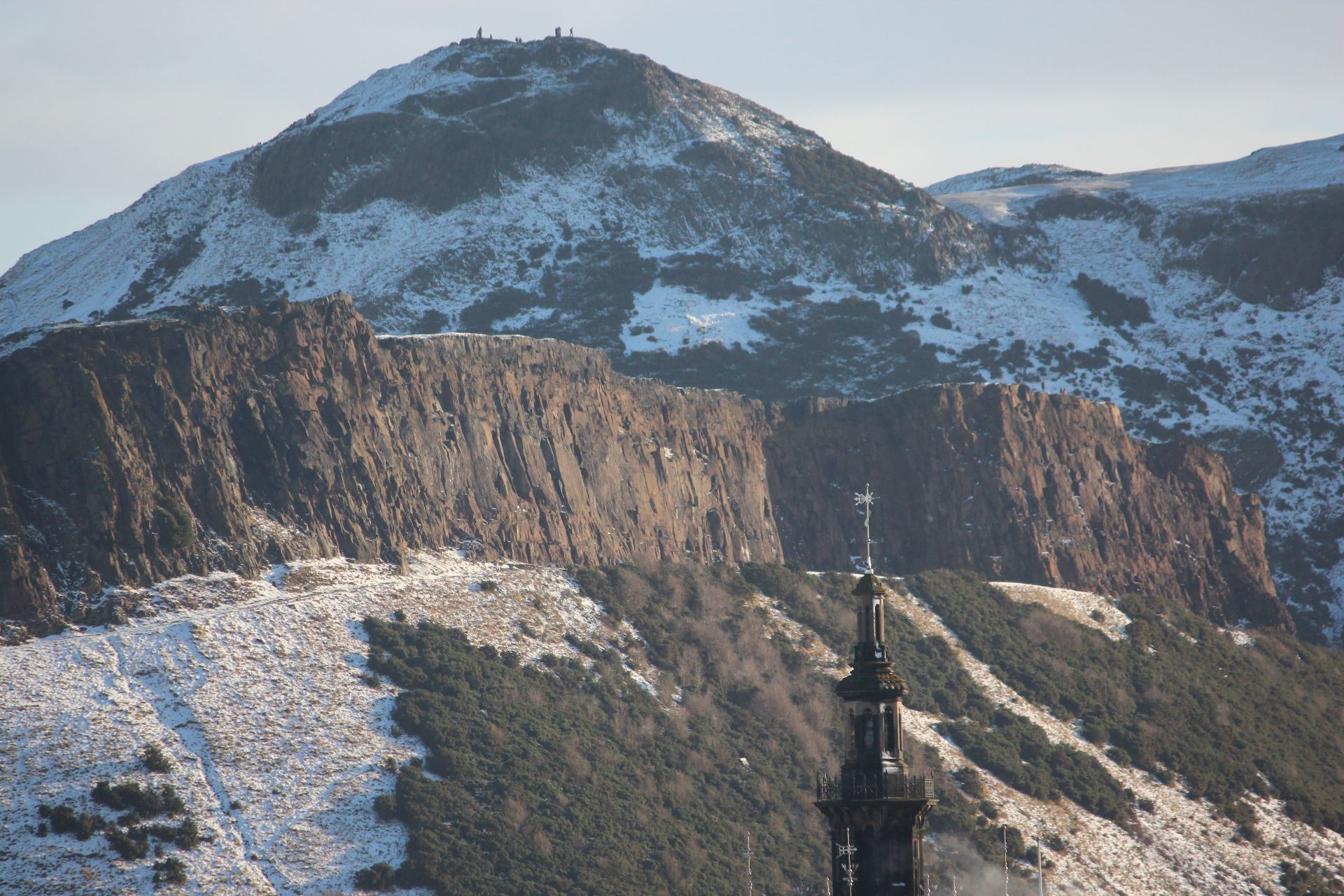
The remains of two fossil forrests can be found on the foreshore and in the cliffs at Ihumatao.
There are two fossil forests at Ihumatao both destroyed in different circumstances over a period of 100,000 years.
The oldest a mature Kauri forest had trees varying in diameter from from 70 centimetres to3 metres. Some of the fossil Kauri trees must originally have been giants rising more than 20 metres into the air before branches sprayed out. What killed the first forest?
It was probably a slow death. Logs and stumps from this forest are found in thick peaty sediment. This may have occurred through natural swamp formation in the area with the forest slowly drowning. Logs and stumps are exposed in cliffs at the top of the beach and on the foreshore where the dark sediment has eroded.
Over time the conditions that produced the swamp changed and the land dried sufficiently for another forest to flourish. Trees found growing in this rich peaty soil included rimu, miro and hinau. About 50,000 years ago disaster struck again. Nearbye Maungataketake exploded into life. Yellowish to brown volcanic ash rained down on the trees stripping leaves from branches and branches from trees. The explosive force of eruptions snapped trunks in two. The remains of the forest was buried in ash and lava bombs .
Rangitoto is Auckland’s youngest volcano. Early eruptions broke out under the sea about 600 million years ago.
Maori inhabitants on nearbye Motutapu witnessed these eruptions leaving trace footprints in ash. Scoria.
As with all volcanos in the Auckland the driving force for activity on the surface is the subduction of the pacific plate beneath the australian plate.
fountained from a central cone and basalt lava flowed freely from its base, overlapping to produce a symetrical shield shape. Mangere mountain is another example of a scoria cone.
The lava flows cooled to from a hard crust on the surface. In places this was broken into slabs by the drag effect of lava flowing beneath.
Lava sometimes drained to leave behind caves which are now open to view after roof collapse.
On the foreshore at the wharf thick syrupy flows can be seen.
Older volcanos North head and mountain Victoria lie accross the Waitemata.
After 600 years there is very little soil on the surface of rocks for plants to grow.
Mosses and lichens would have been the first colonisers. As they died a thin layer of humus formed
Pohutukawa were the first trees to take hold in a very dry environment. The base rock is porous.
After wind borne invaders arrived they attracted birds who brought with them more seeds to grow and develop.
Geology.
The photos.
How to get there.
By Fullers Ferries from Auckland Wharf. The cruise out to Rangitoto also offers the option of taking the Volcanic Explorer a tractor drawn train up the volcano rather than walking. You can cover more ground this :
Bibliography
A Field Guide to Auckland by Ewen Cameron, Bruce Hayward and Graeme Murdoch. Published by Random House New Zealand 2001.
Lava And Strata by Lloyd Homer, Phil Moore and Les Kermode. Published by Landscape publications limited in association with The Institute of Geological and Nuclear Sciences
the shape of the scoria cone (steep sided compared with Rangitoto a shield volcano where the molten basalt flowed freely without a high gas content.)
major landsape features and processes (explosion crater, large southern cone with a smaller cone to the north) Other landscape features including a breach on the eastern side of the southern cone that allowed basalt to flow freely where the football fields are now. Another minor breach that local Maori had to fortify to prevent incursions by unwelcome guests
Assorted lava bombs and evidence of fire fountaining as volcanic activity waned
Human impact through stone gardens, kumara pits. There was substantial quarying as durable basalt and scoria were removed for building purposes.
Watch out for some of the features in the video of the field trip.
The basaltic magma is produced 70Km below the surface as the pacific plate is subducted beneath the Australian plate. It gradually makes it way to the surface and it is only a matter of time before another volcano joins 50 others dotted accross the Auckland landscape
The landmarker walk trails around the mountain, Humps hollows and terraces are traces of a large community that lived in the shelter of the mountain, The formation of the mountain would have been extremely violent.
Two giant tubes carried the lava under the sea and they can be seen in the cliffs as large fan shaped structures. They split open under pressure and lava squeezed out like toothpaste from a tube to form pillow lavas……
Maori Bay
When you stand on the sands at Maori Bay on Auckland’s ruggedly beautiful west coast you can’t help noticing the striking features on the cliffs behind you. Two large feeder tubes carrying huge volumes of andesitic basaltic lava spilled across the ocean floor about 17 million years ago. In time the flowing lava cooled and solidified. Two large large fan shaped structures in the cliffs above the beach remain as evidence of this event. They are thought to be the main feeder tubes that carried the lava under the sea. The radiating columns developed as the lava cooled and contracted
The large feeder tubes split open and lava at about 1000 degrees celsius spilled into the ocean where it cooled rapidly leaving a glassy layer on the surface. This shows up as a light coloured ring around the “pillows”.
Further round the coast in Collins Bay the pillow lavas are overlain by conglomerate.The cobbles and boulders in the fallen block of conglomerate at the southern end of Collins bay would have come from a similar ancient beach.This material would likely have been transported to its present site by a series of landslides. The walls of a large submarine canyon the debris flowed through can be seen in the cliffs a short distance away.
17 million years ago……..
Two giant tubes carried the lava under the sea and they can be seen in the cliffs as large fan shaped structures. They split open under pressure and lava squeezed out like toothpaste from a tube to form pillow lavas……
Underwater processes that produced the pillow Lavas at Maori Bay.
Auckland Volcanoes: Lake pupuke one of the oldest volcanoes of the Auckland field......
…..next to the youngest volcano of the region, Rangitoto……
…..next to the youngest volcano of the region Rangitoto……
It probably started with a huge explosion about 120,000 years ago. Basalt coming from depth finally encountered cold water and blasted large volumes of mud and ash into the air where it fell as a tuff ring roughly where hurstmere road skirts Lake Pupuke today. Molten lava swirled round forest trees close to where the Takapuna boat ramp now sits. Trees with their deadly collar of solidifying lava were incinerated and only the moulds remain today . The remaining lava kept on flowing to devastate other parts of the ancient forest.
There are many examples of the effects of lava flowing through a forest containing some very large Kauri trees along the shoreline from the boat ramp to O’Neils Avenue. Places of interest are numbered. Can you spot them in the flickr photos?
Tree moulds. Swirling lava cooled against trees producing solid blocks about a meter high. The trees incinerated leaving a mould in the centre.
Looks like brown concrete but actually the remains of the tuff ring. Mud, ash clay and sandstone blasted into the air by the original explosion settled and baked solid with heat and moisture when it settled on the ground.
Rocks with gas holes (vessicles). Most holes are near the surface
Blobs of once molten rock that dripped from the roof of a small lava cave. The natural furnace was fuelled by burning charcoal and wood as hot air blew through. Temperatures got high enough to remelt the roof of the cave. A bit like blowing on the embers of barbeque charcoal to get the temperature up.
Gas holes bubbled around the the wood as it roasted and probably blew apart a hole as it tried to escape from the viscous lava.
The Scream…….
120,000 years ago a lava flow streamed through here carrying logs and branches. The wood screamed as it slowly vapourised in the molten lava.

")